Introduction
Ordnance Survey history
Who conducted the survey?
The format of the name books
History in the name books
Sketches in the name books
Gaelic place names
Scots place names
Resources used
Introduction
The Ordnance Survey (OS) Name Books (or 'original object name books' to give their formal name) provide information about every Scottish place name found on the Ordnance Survey six-inch to the mile (1:10,560) 1st edition maps. They comprise the earliest complete gazetteer of Scottish place names. These records have been released on Scotland’s People, along with modern transcriptions for ease of searching and interpretation.
These records will be of particular interest to local and family historians, hoping to gain insight into the evolution of the Scottish landscape and of the places their ancestors worked and lived. They also provide insight into the sources of names, their meanings, different spellings of place names, archaeological finds and the individuals involved in collecting this information.
Ordnance Survey history
The Ordnance Survey has military roots, as it was commissioned to survey the Highlands of Scotland after the rebellion of 1745. Later it charted the vulnerable southern coastline of England as the French Revolution (1789-99) continued across the English Channel. The importance of accurate maps for military strategy was paramount for relocating troops and preparing campaigns. At this time, what became known as the Ordnance Survey was the government’s defence ministry or Board of Ordnance. It comprised teams of military engineers headed by William Roy who created the ‘Great Map’, or the Military Survey of Scotland.
Roy’s survey of the Scottish mainland was the foundation of the OS Name Books and consequently the 1st edition six-inch maps, as they recorded roads, rivers, hills, land cover types and settlements. The Ordnance Survey Act of 1841 was enacted to formalise the operations of the mapping agency for Great Britain and ensured the accuracy of geographic and property data for national security and planning. In the years following this act, the creation of the OS Name Books of Scotland began in earnest.
Who conducted the survey?
The survey was conducted by Ordnance Survey field surveyors, or officers, from 1843. The plan was to start in the central belt of Scotland and then head north. However, it was suggested that areas further north in need of agricultural development should be prioritised. Subsequently, the Isle of Lewis was comprehensively surveyed by the OS. Due to disagreements over which scale should be used and a lack of staffing, it was not until 1859 that the Lowlands were completed.
By 1856, there were six OS officers surveying across Scotland, but they were complemented by 204 privates from the Corps of Royal Engineers, known as ‘sappers’, due to the unit being formally known as the Corps of Royal Sappers and Miners (often abbreviated to Pri [Private] RS&M [Royal Sappers & Miners] in the name books). Also, that same year, 416 civil assistants (abbreviated in the OS Name Books to CA or C/A) and 300 labourers were employed to collect the topographical information.
The format of the name books
The collated information was called ‘original object name books’ and the method used for recording the information in Scotland was largely in two forms, each with a different system of headed columns. The first type, commonly used in surveying and naming the Highland parishes, was a 'field' version of the name book and had five headings: Received name; Object; Description; Township or parish; and Authority for spelling, with their names and addresses.
The collector, usually an officer in the Ordnance Survey or Royal Engineers, would consult local historians and etymologists (‘authorities’) in order to fix the spelling (the received name) of each ‘object’ (natural feature, inhabited place, building, and so on).
A second type, used commonly in the Lowlands, had an additional column: 'Orthography as recommended to be used in the new Plans'. Another column of 'Descriptive Remarks, or other General Observations which may be considered of Interest' usually duplicated the information contained in the 'Description' column, but additional information was sometimes given. This fuller version was completed by staff in the local Ordnance Survey office who might add further information from sources such as early maps, historical texts, or local scholarly bodies.
History in the name books
The Bass (NRS, OS1/1/42 pages 55-56), a feature of the Aberdeenshire landscape in the parish of ‘Inverury’ (usually spelled ‘Inverurie’ today), is described in detail by Captain Edward Henry Courtney of the Royal Engineers. This “conical mound, apparently about 50 or 60 feet high, and of proportionate diameter” is the possible gravesite of King Aoch, son of Kenneth II, who died here in 881. Courtney has taken this information from the Statistical Account of Scotland, a resource frequently quoted by the OS Name Books collectors. However, Courtney notes that the local tradition is that the plague was buried within it, and that “if it was opened, it would prove a kind of Pandora’s box and disperse the seeds of all imaginable distempers”. Courtney’s description of The Bass continues over two pages and even quotes a “well Known prophetic stanza attributed to Thomas the Rhymer”,
When Dee and Don both run in one,
And Tweed shall run in Tay,
Ye little river of Ury
Shall bear ye Bass away.
A Roman Altar “belonging to the Second century” was discovered in Nether Croy, Dunbartonshire, and described in the OS Name Books for the county (NRS, OS1/9/5 page 8). The Roman Altar was found in a “mutilated” state, but the inscription “had escaped uninjured” and is transcribed in full, being “well executed”.
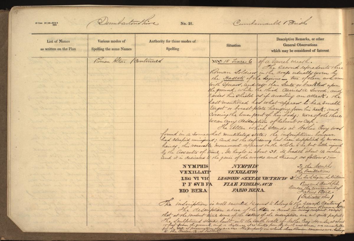
Crown copyright, National Records of Scotland (NRS), OS1/9/5 page 8
This stone altar is now in the collections of National Museums Scotland.
The smallest county of Scotland, Clackmannanshire, has many interesting historical entries. One is for Lookaboutye Brae (NRS, OS1/8/3 page 40):
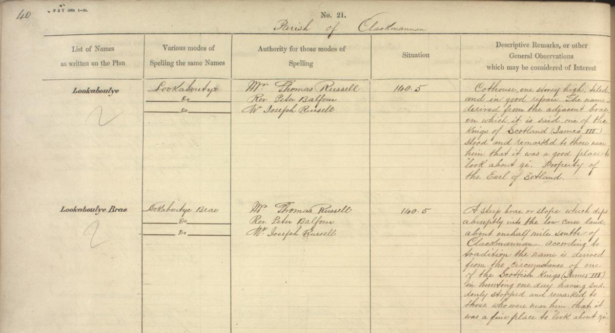
Crown copyright, NRS, OS1/8/3 page 40
This example of the first type of name books is from the Clackmannanshire county name book (NRS, OS1/8/3) which describes the place Lookaboutye Brae. The column headed ‘Descriptive Remarks, or other General Observations which may be considered of Interest’ helpfully informs us of its appearance and the origin of this unusual place name:
“A steep brae or slope which dips abruptly into the low carse land, about one half mile south of Clackmannan according to tradition the name is derived from the circumstance of one of the Scottish Kings (James III) in hunting one day having suddenly stopped and remarked to those who were near him that it was a fine place to "look about ye"."
The spelling of this place name has been confirmed by three individuals, including the Reverend Peter Balfour, seen in columns two and three. The origins of the place name concerns a hunting trip in the area by Robert the Bruce, rather than James III, who lost his glove or gauntlet and instructs his men to ‘look about ye’ for it. Interestingly, the motto for the county is ‘look aboot ye’ and presumably comes from this royal tale. The Clackmannanshire coat of arms also depicts two gauntlets along with the motto, and it is interesting that the story is cited in the Victorian OS Name Books.
Sketches in the name books
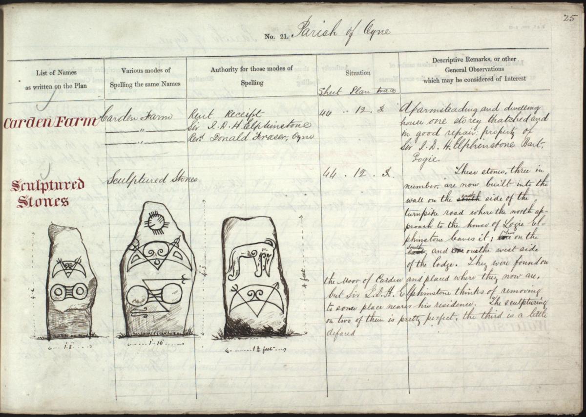
Crown copyright, NRS, OS1/1/70 page 25
This sketch of three Pictish symbol stones can be found in the Aberdeenshire OS Name Books (NRS, OS1/1/70 page 25). The description tells us that they were found in the Moor of Carden and “now built into the wall on the east side of the turnpike road where the north approach to the house of Logie Elphinstone leaves it”. The collector also details Sir J D H Elphinstone’s plans to move them closer to his residence, which was carried out after the survey. The collector also states that “The sculpturing on two of them is pretty perfect, the third is a little defaced.”
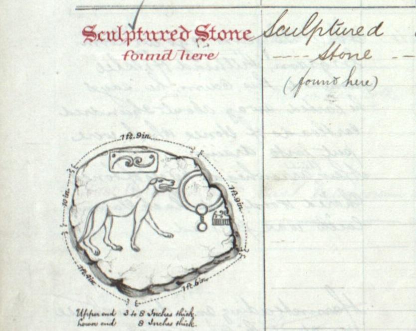
Crown copyright, NRS, OS1/1/54 page 24
This beautifully rendered Pictish symbol stone of a wolf was discovered by an OS collector at Newbigging Farm in Leslie, Aberdeenshire. The description says that “The stone is of the kind locally known as "Bennachie Stone" and when found was in a sloping position having the sculptured face facing Bennachie”. This stone now stands nearby in the garden of Leith Hall (NRS, OS1/1/54 page 24). A modern photograph of the stone can be found on the University of Aberdeen’s website.

Crown copyright, NRS, OS1/9/15 page 41
Not all of the sketches in the OS Name Books concern finds from the Middle Ages. Here we have a sketch of the growing railway network in Scotland, depicting Dunbartonshire Junction in Old Kirkpatrick parish. The sketch has the abbreviation ‘O.M.O’ beneath it, for Ordnance Mapping Office (NRS, OS1/9/15 page 41).
Gaelic place names
Most of the Gaelic place names in the Highlands and Islands had never been written down before the creation of the OS Name Books. In some instances, there are many corrections and annotations in the books due to the determination of the meaning of Gaelic names and how they should be spelt. Therefore, errors in spelling should be expected.
The Gaelic place name of Beinn An Fhaireachaidh or Beinn na Faire (NRS, OS1/18/7 page 156) in the Outer Hebrides is explained in the Inverness-shire name book: “This name signifies "Watching" and applies to a heathy clad hill of four, or five, hundred feet in height”. The authority of the spelling of the name comes from a local tenant, Mr E. McDonald, of Lochmaddy.
Creag Nam Feannag in Caithness features the Gaelic word for crow - ‘Feannag’ and is described as “two Conspicuous rocks, a little way to sea surrounded at Low water opposite ''Poll - Bathadh'' […] ''Creag [rock or cliff] of the hooded Crows''. The final note sadly states: “A common form of corruption in all districts where the gaelic is dying out” (NRS, OS1/7/15 page 191).
Scots place names
The Scots language inevitably influenced many of the place names across Scotland. Many of the naming terms come from the natural habitat and wildlife of the surrounding landscape.
In the Berwickshire name books we find the place name Brockholes (NRS, OS1/5/10 page 3), ‘brock’ meaning badger. The name book describes Brockholes as:
“A steep and lofty hill near Grants House, sloping to the Banks of the Eye Water, It is supposed to obtain its name from a number of Brocks (badgers) having made their Holes on the hill side.” Brocks can be found in the naming of many places across Scotland.
The Scots word for seal, ‘selchie’, can be found in many place names around the coastline. Here ‘Selchie Geo’ in Shetland has some explanatory notes added by the OS collector. ‘Geo’ in Scots means an inlet of the sea with steep rocky sides.
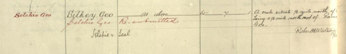
Crown copyright, NRS, OS1/31/10 page 54
In Scottish folklore a ‘Selkie’ was a mythological creature that could shapeshift between human and seal forms.
Gowk’s Hill in Banffshire (NRS, OS1/4/6 page 6) has a brief description, explaining the name’s origin in Scots and its appearance: “This name means literally the Cuckoo's Hill. A Small Eminence Covered with fir wood and Situated north of the farm of Bodinfinnoch.” The collector, M. Campbell, C/A [Civil Assistant], has also referred to the Valuation Rolls for the county to assist with the spelling of place names on the same page:
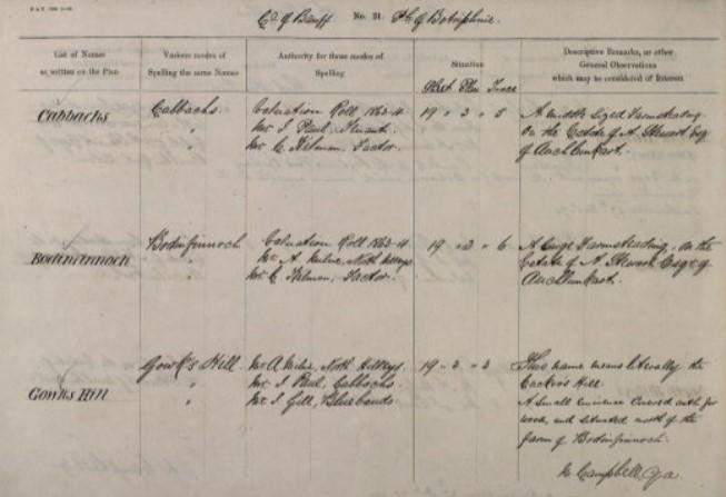
Crown copyright, NRS, OS1/4/6 page 6
Although many of the place names or ‘objects’ featured in the name books have detailed descriptions, and sometimes illustrations, to help convey information, sometimes the collector is at a loss for words or explanation. The Big Stone of Morangie (NRS, OS1/28/29 page 38), located near the Glenmorangie Distillery in the parish of Tain, Ross and Cromarty, has the distinction of being inscribed with the words "The Immortal Walter Scott O.B. 1832”. This inscription is far from clear, however, as there seems to be few links with the area and the writer. The description states that:
“This Stone Stands about 7 feet high, is of an oblong shape, the upper portion being rounded off by the action of the weather. The grandfather of the present proprietor [H. Rose] has had cut on the portion facing the road the following sentence: "The Immortal Walter Scott O.B. 1832. There is nothing more known about it, it is simply a big stone, hence its name.”
The OS Name Books are a rich source for researchers of the nineteenth century. They can include information on social history, folklore, and the natural landscape. As we have seen, these records can offer insight into the evolution of the Scottish landscape and of the places our ancestors worked and lived. They also provide understanding into the sources of names, their meanings, different spellings of place names, archaeological finds and the individuals involved in collecting this information.
The OS Name Books are now available to view for free in the Virtual Volumes area on Scotland’s People. You can search the records by reference; by county, city, place or town; or by a transcription keyword. You can also search county lists of names of buildings and geographical features. Further guidance can be found in our OS Name Books record guide.
Resources used
Dictionary of the Scots Language
Learn Gaelic Dictionary
Ordnance Survey Maps, Six-inch 1st edition, Scotland, 1843-1882: A Scottish paper landscape
Ordnance Survey People
Ordnance Survey history