Two and a half centuries of Glasgow’s history are reflected in more than 40 maps and plans of the city and its environs included in the initial release on ScotlandsPeople.
Among the earlier maps is a colourful and very informative depiction in 1764 of the course of ‘the Rivulet Molendinar’, which ran to the east of the High Street (RHP3945). The map shows the layout of the city south from the College (the University of Glasgow on its old site) down to the Clyde and the main streets, including the Trongate, Gallowgate and Saltmarket. Building plots, closes and wynds are shown, as well as churches, an episcopal chapel and bowling greens. The map comes from a Court of Session case brought by the aggrieved owner of a saw mill. In 1764 it was demolished by the city authorities because of complaints of flooding caused by the damming of the Molendinar burn. The map depicts the site of the mill near the river, and the elevations of four bridges and a dam upstream. In 1768 this map and a drawing of the saw mill (RHP3946)were combined in an engraved record of the case. The original drawings and the court case are held in National Records of Scotland.
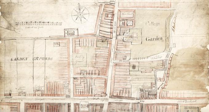
Detail from a plan of the city of Glasgow showing the course of the Rivulet Molendinar.
National Records of Scotland, RHP3945
The selection of maps provides snapshots of the growth of the city from the late eighteenth century onwards, especially during the following century. An engraved plan of the estate of Kelvinside and Gartnavel dated 1867 has been marked up in 1872 to show new features such as roads and the lines of water pipes to the west and south of the Botanic Gardens (RHP351). In Glasgow’s east end an engraved map of 1837 shows areas of ground being offered along the new London Street (RHP93). A century later a six-inch Ordnance Survey map of the east half of Glasgow shows the proposed extension of the city’s boundary to embrace the ancient burgh of Rutherglen in 1934 (RHP40577). Rutherglen did not become part of Glasgow until 1975.
A drawing of a tenement in King Street shows how in 1799 it was proposed to modernise its façade by replacing the unfashionable crow-stepped dormers with a raised wall and conventional rectangular windows (RHP6005). Other later drawings depict buildings of several kinds across the city.
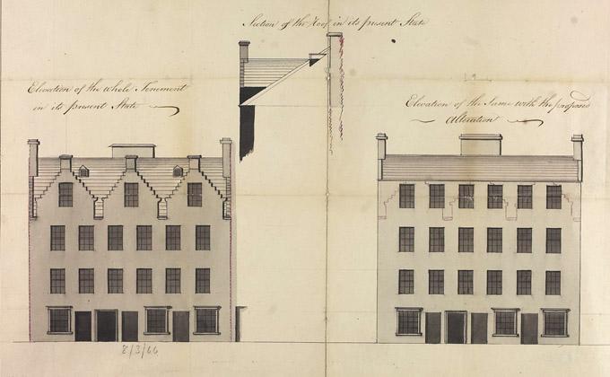
Elevation of a tenement in King Street, Glasgow, 1799.
National Records of Scotland, RHP6005
Duke Street Prison was a familiar city landmark, and all too familiar to the male and female prisoners who are listed in the prison registers in National Records of Scotland. The prison stood in the angle of the High Street, Duke Street and Drygate. A block plan of 1880 helpfully shows the functions of the various buildings, its three exercise yards and the site of proposed new buildings, including a wing of 100 new cells to replace the old prison (RHP6570). Duke Street finally closed in 1955, having been replaced by Barlinnie Prison.
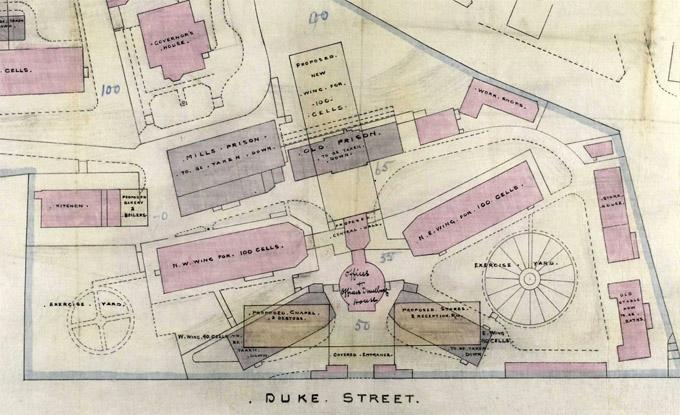
Detail from a plan of Duke Street Prison
National Records of Scotland, RHP6570
Several maps and plans reflect the importance of the Clyde and the canals and railway lines that made up Glasgow’s transport infrastructure in its industrial heyday. An 1890 plan of the Glasgow Subway shows the circular route that is essentially unaltered to the present day (RHP6581). However, the cityscape it traversed, with its concentrated mass of shipyards, docks, factories and workers’ housing, is utterly different.
Three plans of Hutchesontown and part of the Gorbals in 1956-7 show how improvements to housing and the urban environment were made by the City Corporation as part of the rapid transformation of Glasgow’s fabric after the Second World War. 'Let Glasgow Flourish!'
Learn more about the maps and plans collection in our online guide. Further reading: John Moore, 'Glasgow: Mapping the City' (Birlinn, 2015)