Coal Board statutory working plans
Introduction
What Coal Board statutory working plans are available on ScotlandsPeople?
How to search Coal Board statutory working plans
Understanding the content of the Coal Board statutory working plans
Related records
Glossary
Introduction
National Records of Scotland (NRS) holds 4,865 National Coal Board statutory working plans of abandoned and current workings (NRS, RHP146000) created under requirements of the Mines and Quarries Act 1954. These plans were created between 1955 and 1989 as a response to the Mines and Quarries Act 1954 . This act required mining managers to keep accurate plans of abandoned and active workings in the mine, as well as all other workings within the boundaries of the mine or within a prescribed distance of the mine. Additionally, sections of the seams or veins of working coal and their overlaying strata were sometimes included.
These plans cover much of the central belt of Scotland and have generally been catalogued from left to right, from Ayrshire through to Stirlingshire. Only areas with active or abandoned coal workings are represented, including underwater workings.
These plans are not official abandonment plans. Workings must be verified as to their completeness and accuracy in the official abandonment plans available from the Mining Heritage Centre, 200 Lichfield Lane, Mansfield, NG18 4RG; or the British Geological Survey, Research Avenue South, Edinburgh, EH14 4AP.
What Coal Board statutory working plans are available on ScotlandsPeople?
The following counties are represented in this release:
• Ayrshire
• Clackmannanshire
• Dunbartonshire
• East Lothian
• Fife
• Glasgow
• Kinross-shire
• Lanarkshire
• Midlothian
• Perthshire
• Renfrewshire
• Stirlingshire
• West Lothian
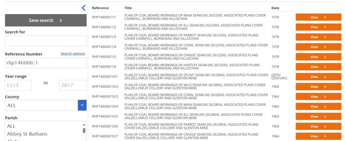
How to search Coal Board statutory working plans

Screenshot of the search page.
Crown copyright, NRS.
You can search for these plans in the maps and plans section of the ScotlandsPeople website in several ways:
• By keyword (colliery name, seam name, landmarks)
• By reference number (typing ‘RHP146000’ in the reference number field and selecting ‘Reference begins with’)
• By county/parish, using the drop-down menu
Please note, if you select a county, the parish menu will refresh to only include parishes from that county; if ‘all’ counties are selected, any parish can be selected from the entire list.
Screenshot of the search results page.
Crown copyright, NRS.
Once you have made a search, all associated plans should be visible on the results page.
Parish level indexing
Utilising the parish boundary viewer on the National Library of Scotland’s website, plans have been indexed to parish level. In this record set, many of the plans span over more than one parish, and so will appear when several parishes are selected within the drop down menu. It is also worth noting that any given coal seam may cross over several parishes.
For an overview of how these plans fit together, please navigate to the link to the Collieries across Scotland plan below which will open in the same web page:
This visual shows the scope of the Statutory Working Plans and their locations across the central belt of Scotland. You can use the plus and minus buttons in the document header to zoom in and out of the plan. The number in each box links to the ‘bundle’ number for each set of plans. To find all the plans in a given bundle in the Maps and Plans section on ScotlandsPeople, search for ‘RHP146000/XXX’, where ‘XXX’ is the number found in the relevant box above.
Underwater seams
• Any plans that are of open ocean have been linked to the closest on-land parish. Please note that in some cases there may not be any coastline visible on the plan. If this is the case, please look at the national grid reference to establish the nearest parish.
• Any plans that include the Firth of Forth have been indexed as both the nearest on-land parish, and ‘Firth of Forth’.
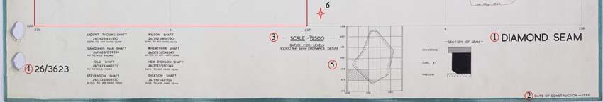
Understanding the content of the Coal Board statutory working plans
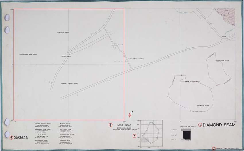
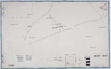
1. Seam Name
2. Date of construction
3. Scale information
4. National Grid reference
5. Reference to larger area
6. Bottom left corner of second National Grid square
NRS, RHP146000/3. This copy is provided under the terms and conditions of ScotlandsPeople. This is not an official abandonment plan. Workings must be verified as to their completeness and accuracy in the official abandonment plans available from the Mining Heritage Centre, 200 Lichfield Lane, Mansfield, NG18 4RG or The British Geological Survey, Research Avenue South, Edinburgh, EH14 4AP.
In this example, the set numbered RHP146000/3 contains five plans: - RHP146000/3/1-5. Each of these plans includes the grid reference number ‘26/3623’. Wherever possible, landmarks, shaft names, and locations have been noted in the titles to assist with searching. In this case: ‘Associated plans cover Mount Thomas Shaft, Sanquhar Shaft, Old Shaft, Stevenson Shaft, Wilson Shaft, Wheatpark Shaft, New Dickson Shaft and Dickson Shaft’.
As part of the Ordnance Survey National Grid reference system, the ‘26’ portion of this number can also be written as ‘NS’. This means that the reference numbers on these plans will be in either of the following formats:
• NS/3823
• 26/3823
All six of these plans show the same area of land, and feature the locations of pits and seams focused on different types of coal.
What can the plans tell us?
Each bundle of plans should be viewed in relation to each other. For example, RHP146000/38 includes five plans.
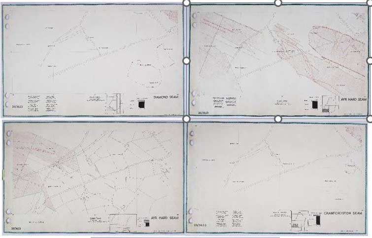
All five of the plans in this bundle show the same area of land, 26/3623, and each plan shows the extent of a specific seam of coal within that area. Each plan covers a 1 x 2km area, and the given National Grid reference number (in this case, 26/3623) relates to the left most 1 x 1km square of the rectangle. The grid reference number for the second 1 x 1km square is not noted, but in this instance it would be 26/3723.
Not all geographical features are labelled on each individual plan, and only the key features have been noted in the catalogue. If you are having issues finding a specific place, please look at the grid reference to get an idea of where best to search or consult the Ordnance Survey Website for more information on the National Grid.
Related records
For more information on other coal-related records we hold, as well as examples of records held elsewhere, please see the Coal Mining Records research guide on the NRS website. For more information on other maps and plans in our collections, please see the guide on the ScotlandsPeople website.
Glossary
Most glossary terms have been taken from the Dictionaries of the Scottish Language.
- Blackband: Earthy carbonate of iron, containing bituminous matter
- Cannel: A kind of coal which burns with a strong light, also called candle coal, is a gas coal
- Cherry coal: A bright freely-burning coal; from its glowing red in the fire or breaking into small round lumps
- Coking: Grad of coal that produces good quality coke, which is essential for blast furnace process of steelmaking
- Craw: Also called craws, or crow coal, usually a thin seam of inferior coal
- Duddy Davie: The name of part of the Jubilee seam of Bowhill
- Ell: Normally found in seams averaging one ell in thickness (a unit of linear measurement of 37.059 inches in Scotland)
- Fire: Soft, bright-burning coal, also called seeing-coal, of a rich and caking quality
- Fireclay: Clay strata excavated along with the coal and used for making bricks
- Gas: Coal yielding gas of high illuminating power on distillation, of lustreless appearance, and having a conchoidal fracture, also called licht-coal, candle coal
- Great Coal: Large pieces of selected coal. In the East of Scotland, the coal was formerly divided into four grades: great coal, chews, lime-coal, and panwood'
- Humph: A name given to poor quality coal; ‘Humphed Coal’ is an inferior coal found near whin, Also used attrib. Hence comb. Humphed coal, “coal altered by contact with whin; inferior coal”
- Ironstone: A stratum containing iron in combination with carbonaceous and argillaceous matter.
- Jewel: Special high grade coal with a clear shining surface
- Jubilee: Named for first reaching the coal on Queen Victoria's jubilee
- Lime: A small coal used for lime-burning
- Little: A rather soft cubical coal of high quality
- Main: Good quality coal, apparently used for gas-making purposes
- Meikle: Of size or bulk; large, great, big
- Mosie / Mozey: A coal seam of variable thickness in the Clackmannanshire coalfield
- Parrot Coal: A highly volatile bituminous coal which ignites easily and burns with a clear bright flame and a crackling sound, sometimes referred to as cannel coal, a gas coal
- Peacock Coal: Similar to Eenie Coal: Coal slightly altered through nearness to whin, the broken edges of which shew bright circular spots more or less distinct, like eyes
- Smithy / Smiddie: A small smokeless type of coal suitable for smiths' work, one which forms a coke of small pieces
- Splint: A hard, coarse bituminous coal which tends to splinter when fractured and burns with great heat; between cannel coal and common coal
- Stink(ie): Stinking-coal, an impure variety of coal which burns with a strong sulphurous smell
- Top Coal: The uppermost of two or more divisions of a seam of coal
- Upper hirst: Suitable for power station use, slow-burning and good for manufacture of salt and glass, known locally as the Jenny Pate or Janet Peat
- Wee: A shallow seam coal, sometimes also called 'upper'
- Whin: Another name for gorse